Congestion Free Network 2
Greater Auckland is proud to present the Congestion Free Network 2
Auckland is a city in transition. We are no longer the car dependent ‘overgrown town’ of the late 20th century. Yet we are also not yet a true world-class city. Auckland has come so far in the past 15 years, but we also still have so far to go.
Auckland is increasingly different from the rest of New Zealand. We are younger, more diverse, more educated and more productive. We are also growing much faster and will continue to do so. There is no going back to the Auckland of old.
Yet Auckland faces immense challenges as we grow and transition from an overgrown town into a world-class city. The narrow isthmus that makes Auckland such an attractive place to live also makes our city relatively difficult to get around. A history of neglecting public transport has caught up with us, despite recent progress.
Auckland needs and deserves a bold transport vision. We need a realistic alternative to get around that is fast, reliable and attractive. We need a network free from congestion, a Congestion Free Network.
It is now nearly four years since we launched the original Congestion Free Network in July 2013 and much has changed. Encouragingly, much of our original CFN has been adopted by both Auckland Council and Central Government, through the Auckland Transport Alignment Project (ATAP).
Key parts of the CFN are being progressed: the rail network is now electrified, City Rail Link is under construction and busways to the north, northwest and southeast are under development. A completely reshaped bus network is being implemented and we now, finally have both integrated ticketing and integrated fares.
With the adoption of the Unitary Plan, we have also learned a lot more about how Auckland will grow in the future and what that growth means for our transport network. Put bluntly, unless we invest heavily in serving new “greenfield” growth areas with congestion free transport options we will repeat the expensive, disastrous, mistakes that litter our history. Similarly, as existing urban areas intensify we will need to shift more people in the same amount of space – a task that is simply impossible by car.
Aucklanders have flocked to buses, trains and ferries over the past four years, especially where major improvements have been made. During this time, annual ridership on the rail network and the Northern Busway – our still embryonic CFN – has grown from 12.3 million to 22.9 million.
With such momentous change, it’s time to re-look at the Congestion Free Network and to align it with present day conditions. With ATAP showing government’s agreement, that Auckland needs a strategic public transport network – what we call a “Congestion Free Network”, the debate now is not if we should build it, but when.
WHAT IS A CONGESTION FREE NETWORK?
The Congestion Free Network forms the backbone of Auckland’s future public transport network, supported by further bus and ferry networks. As the name suggests, the key purpose of this network is to provide a way of travelling that is free from congestion. This means rail, light-rail and bus services operating in their own right-of-way that are fast, frequent and reliable.
All great cities have a Congestion Free Network – be it the London Underground, the New York Subway or the Paris Metro. These networks provide the opportunity for vast numbers of people to travel in a way that makes congestion irrelevant. They also mean road networks can focus on the jobs they do well – for freight, commercial travel and highly dispersed trips, rather than having to cater for high volumes of trips along highly constrained corridors.
Having a Congestion Free Network therefore balances the city’s transport system, making the whole network work better.
WHAT’S IN CFN 2?
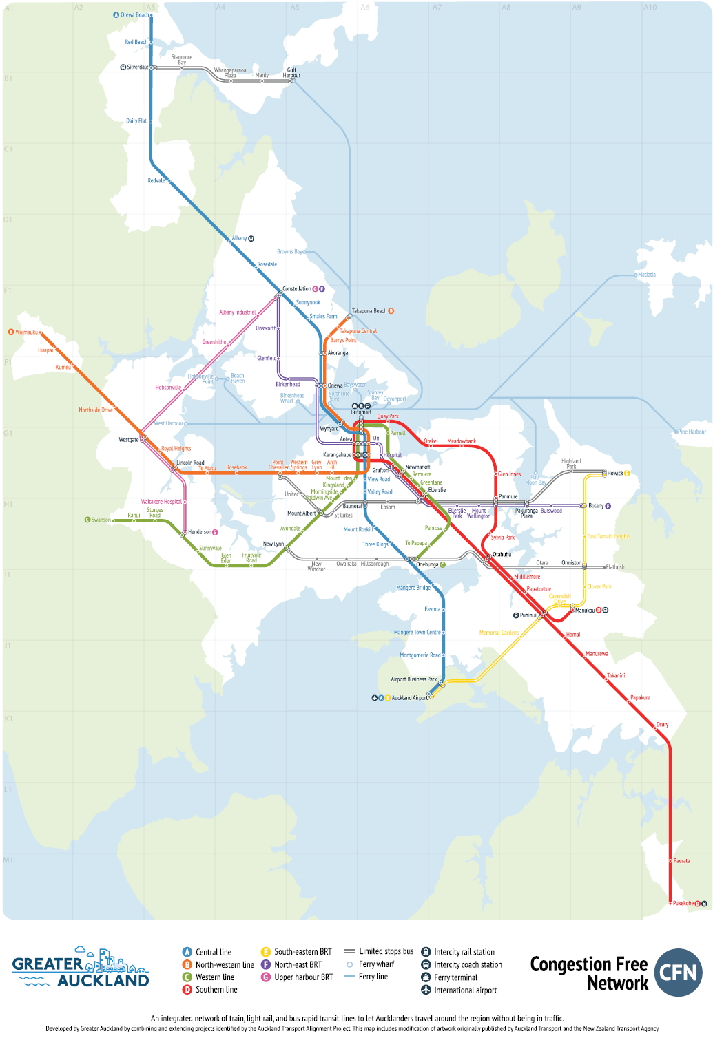
CFN2 has seven key routes: two light-rail, two heavy-rail, three bus rapid transit (BRT). It also contains three enhanced bus routes.
Light Rail Lines
New and improved mass transit lines connecting the North Shore, Northwest, the Isthmus and the airport have been identified as key strategic routes. We suggest these should be connected together in two lines to form a second, high-speed, high-capacity network to complement our improving heavy rail system. We believe modern, light-rail – building upon Auckland Transports recent investigations and with vehicles capable of carrying up to 500 people each – would be the most appropriate mode for these routes.
A. Central Line. This new ‘North-South’ line forms a spine for Auckland’s public transport system, running from Orewa in the north to the Airport in the south. It serves the growing Dairy Flat area, the North Shore, the city centre, central isthmus and southwest part of the city out to the Airport.
B. North-western Line. This new line runs from Waimauku in the fast-growing northwest, through to Westgate and along State highway 16, joining the Central Line though the city centre and across the Waitemata Harbour, before branching off to Takapuna.
Heavy Rail Lines
The City Rail Link turns our existing rail network into a high frequency two-line system. This is enhanced with further improvements the network, such as signalling, junction improvements and removing level crossings, to provide improved service and reliability.
C. Western Line. This heavy rail line takes advantage of the City Rail Link to join up the current Western and Onehunga lines. Enabling higher-frequencies on the Onehunga Line will require double-tracking and the removal of a number of existing level crossings between Onehunga and Penrose.
D. Southern Line. Like the Western Line, this utilises the City Rail Link to join up the existing Southern and Eastern lines. Additional tracks and BRT enable express services to run from Puhinui to Newmarket with only two intermediate stops. A high-quality bus/rail interchange will be provided at Puhinui.
Bus Rapid Transit Lines
Like the Northern Busway today, these routes utilise large amounts of dedicated busway infrastructure and other priority measures to ensure services are fast, frequent and reliable. They may be suitable to upgrade to light rail in the future.
E. South-Eastern BRT. This line connects the Airport with Puhinui (to link with the rail network), Manukau, Flat Bush and Botany. It provides a fast route to the Airport for people living in south and southeast Auckland and also supports the growing metropolitan centre of Manukau. With bus capacity along this route likely to be less constrained compared to the city centre, we envisage the most appropriate mode being high-quality bus rapid transit, operating in its own right of way.
F. North-East BRT. This line utilises the Eastern busway from Botany to Panmure, linking through to the city via Great South Road and onto the Onewa Road corridor, to serve the western part of the North Shore. As the route supplements other lines (particularly A and D), we envisage bus rapid transit to be an appropriate mode, utilising the existing harbour bridge.
G. Upper Harbour BRT. This line connects Henderson and Albany through the fast-growing northwest. It provides congestion free travel along Lincoln Road, utilises the SH16 shoulder lanes to Westgate, before travelling along SH18 to Constellation Station where it connects to Line A. Expected demand levels and less constrained terminus points mean bus rapid transit is an appropriate mode for this route.
Limited Stop Bus Lines
H. Two limited stop bus lines provide for cross town connections while a third connects Silverdale to Gulf Harbour. These routes are a step between traditional bus routes and the dedicated infrastructure of bus rapid transit. They would use standard bus priority measures and only stop major locations to provide fast and reliable cross town services between the key CFN routes. These could potentially be upgraded to BRT in the future.
WHAT’S CHANGED FROM CFN 1?
In the four years since CFN 1 was published, Auckland has taken huge strides towards making our vision a reality.
- The City Rail Link, still the core of Auckland’s future public transport network, is now under construction.
- The Eastern busway (formerly AMETI) in the southeast and the Northern Busway extension to Albany are being designed and consented.
- The Northwest Busway is now accepted by all parties as a key priority for completion within the next decade.
CFN 1 now forms the basis of the Strategic PT Network outlined in ATAP, a vision now shared by Council and Central Government.
But the world has also moved on from 2013 and we know much more about where Auckland will grow, and our future transport needs and challenges. This has led to three key changes from CFN1:
- Introducing a 90 kilometre light-rail system to Auckland across two main lines that extends rail-based congestion free transport to the northwest, the North Shore, the central isthmus and the Airport. These are not “dinky trams”, but rather a grunty core part of the overall network with 66 metre long vehicles carrying up to 500 people each and travelling at up to 110 km/h when possible.
- Three key “cross town” limited stop bus corridors to supplement the rail and bus rapid transit routes. The northernmost route, from Gulf-Harbour to Silverdale, serves the Whangaparaoa Peninsula; while the other two (Pt Chevalier to Howick and New Lynn to Flat Bush) cut across the central isthmus and connect to multiple north-south lines (Lines A, B, C, D, E and F).
- Further extending the CFN into greenfield areas, including light-rail to the north and northwest to complement the existing heavy rail that serves the south. Ensuring a strong commitment to early investment in these areas is critical to their future urban form, creating transit-oriented developments that avoid the growth mistakes Auckland has made in the past.
But the main way CFN 2 is different, is because the focus must now shift from what the vision is, to how we make it happen. The CFN largely aligns with what is proposed in ATAP, and agreed to by Council and Central Government. But ATAP is simply too slow when it comes to implementation. Public transport in ATAP is still, too often, the intervention of last resort only progressed after road widening has – once again – proven to be a failed strategy.
The CFN takes a different approach. We outline a clear way forward to make ATAP’s “strategic public transport network” happen much faster. All up, government costings show the CFN to cost around $13-14 billion – barely one-sixth of ATAP’s total 30-year transport programme and therefore clearly affordable.
NEXT STEPS
The focus of CFN2 is, therefore, on how to make it happen. Here the ball lies mainly in Central Government’s court as it holds most of the purse-strings and levers, but Auckland Council and Auckland Transport play key roles too. Key decisions need to be made for the CFN to become a reality:
Government & NZTA | Auckland Council | Auckland Transport |
|---|---|---|
|
|
|
|
|
|
|
| |
|
We want CFN 2 to become a reality. Over the coming days and weeks we’ll be discussing the CFN 2 in more detail, including looking closer at what’s proposed for each part of the region along with many of the decisions we made along the way.
Much of this has been captured by Harriet in our CFN Report (26mb) which also looks amazing thanks to the design genius of Cornelius from Frontier for the design – who is also behind our website.
You can also see a more detailed version of the map. Feel free to download, print, distribute, draw on, set alight, decorate your room, or re-blog.
 Processing...